Acuity Provides Custom Solutions for Unmanned Autonomous Vehicle Projects

March 2021 MARIETTA, GA ~ Unmanned Autonomous Vehicle projects depend on sensors to provide spatial information for route planning and crash avoidance. A developer of an unmanned airplane selected Acuity’s AR3000 distance sensors to measure the height above the ground, whether it was the landing strip, grass, trees, or mountains. They needed a sensor that could measure long distances to surfaces of different reflectivities.

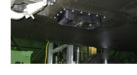
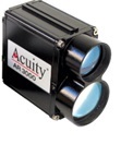
In their first trials, the engineers determined that the standard AR3000 could not accurately measure height above black tarmac at close ranges (<8 meters). It was later learned that not enough laser was reflecting off this dark surface and back into the collection lens. So instead, Acuity offered a new customized version of the AR3000 with a larger laser divergence (10 mrad instead of 2 mrad).

This modified sensor device gave improved measurements at close ranges, but diminished the overall, long-range capabilities. This is how the customer arrived at a dual-sensor system. The first distance measurement sensor measures from 0-50 meters and the second sensor measures from 10-300 meters.

AR3000 distance measurement sensors are Acuity’s longest-range models. Ideal for measuring positions of cranes and trolleys, the time-of-flight sensor can measure up to 300 meters to natural surfaces and up to 3,000 meters when using a retroreflective target.

To prevent cross-talk between the two laser sensors operating at the same 905 nm wavelength, the engineers used a hardware signal to trigger alternating measurements between the devices. This same technology solution has been used by NASA AMES Research Center in Moffet Field, CA.

For more information on Acuity’s sensor solutions click here

If you need a product recommendation please e-mail sales@flwse.com